Guide · Madeira
Hiking in Madeira in 2026the peaks, São Lourenço, Caldeirão Verde, 25 Fontes and Fanal, with fees, status and safety
Madeira's mountain and coastal hikes from official data: PR1 Pico do Areeiro to Pico Ruivo, PR1.2, PR8 São Lourenço (works since 30 Sep 2026), PR9, PR6 and Risco, Fanal. Lengths and status from IFCN, the 2026 fees, weather warnings, trailheads.
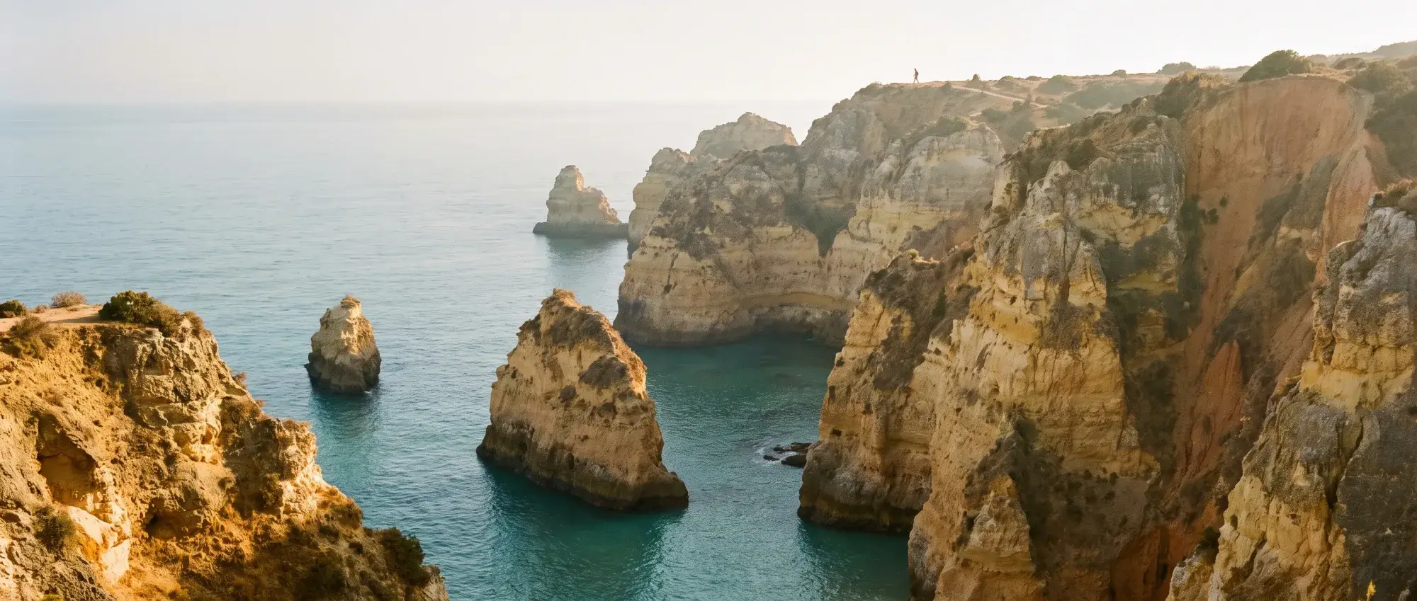
Trail statuses read on 11 October 2026 from IFCN’s official list, last updated on 2 October 2026. They change with weather and works: check the list on the morning you walk.
Short answer: Madeira’s main hikes are on its official PR trails, most of them run by the forestry institute IFCN. In 2026 each IFCN trail needs a time-slot booking on the SIMplifica portal; the standard fee is €4.50, or €10.50 for the full PR1 from Pico do Areeiro to Pico Ruivo [2]. On 11 October 2026 every hike on this page is open, with two catches: PR1 is one-way beyond the Pedra Rija viewpoint and PR8 São Lourenço has repair works with small signposted diversions until at least mid-2027 [1][9]. On the peaks, fog, wind and cold can change a short walk quickly, so check IPMA’s warnings and IFCN’s list before you set out [10][11].
This page is research, not first-hand. Lengths and trail status come only from IFCN. Its trail list and trailhead panels give no difficulty grade, so for effort we give the panels’ time and altitude range.
The hikes at a glance
| Hike | IFCN length | IFCN panel time | Altitude (panel) | Status 11 Oct 2026 |
|---|---|---|---|---|
| PR1 Pico do Areeiro–Pico Ruivo | 6.1 km, one-way beyond Pedra Rija | not on a panel we could read | 1,818 m start [16], 1,862 m summit [4] | Open, western path only [1] |
| PR1.2 Achada do Teixeira–Pico Ruivo | 2.8 km each way | 1 h 30 | 1,592–1,862 m | Open [1][4] |
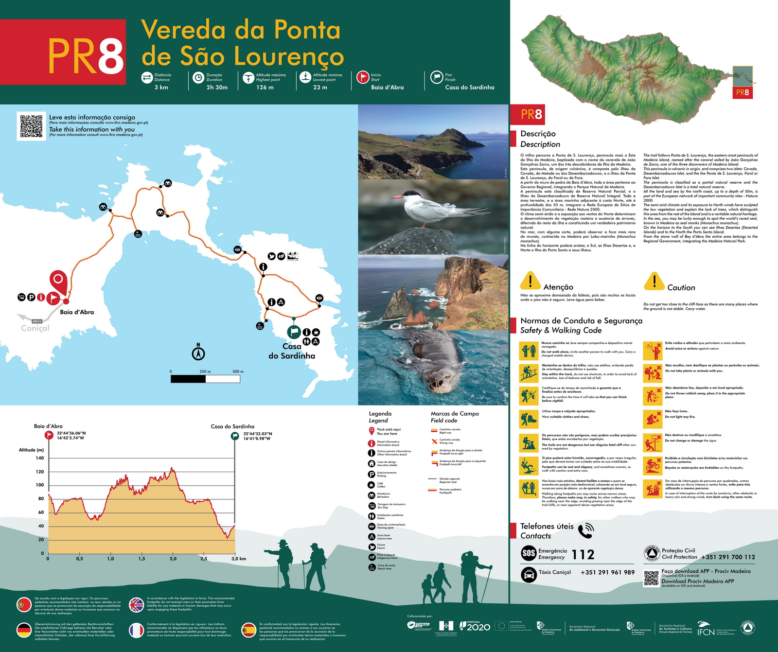
| PR8 Ponta de São Lourenço | 4 km each way | 2 h 30 (panel shows 3 km) | 23–126 m | Open, works [1][6][9] |
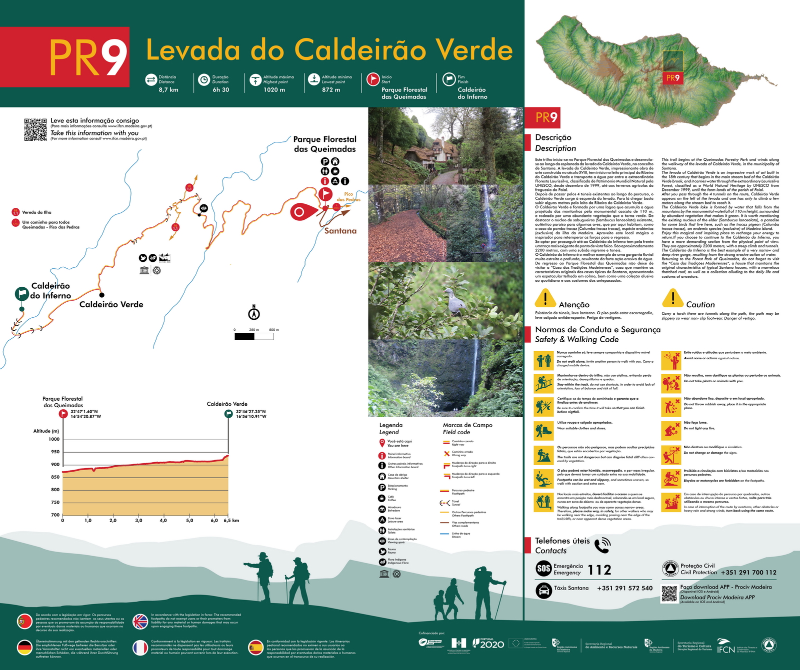
| PR9 Levada do Caldeirão Verde | 8.7 km each way | 6 h 30 | 872–1,020 m | Open [1][7] |
| PR6 Levada das 25 Fontes | 4.3 km each way, one-way circuit | 3 h | 964–1,288 m | Open [1][5] |
| PR6.1 Levada do Risco | 3 km each way | 2 h | 1,000–1,288 m | Open [1][5] |
| PR13 Vereda do Fanal | 10.8 km, linear | 4 h | 1,130–1,420 m | Open [1][8] |
The panels don’t say whether a time is one way or return, so plan with a margin and finish before dark.
The peaks: PR1 and PR1.2
PR1 Vereda do Areeiro crosses the central ridge from Pico do Areeiro (1,818 m [16]) to Pico Ruivo, at 1,862 m the highest point of the archipelago [4]. IFCN lists it as 6.1 km [1]. On 11 October 2026:
- Western path only. The route is open through the tunnels on the western path; the eastern variant via Pico das Torres is closed [1].
- Two-way only to Pedra Rija. Between Pico do Areeiro and the Pedra Rija viewpoint you can walk out and back. From Pedra Rija to Pico Ruivo the trail is one-way, Areeiro to Ruivo, and the full route starts at Pico do Areeiro, not at the Pedra Rija gate [2][1].
- No return the way you came. You leave Pico Ruivo by PR1.2 to Achada do Teixeira or PR1.1 to Ilha (8.2 km), and IFCN says it doesn’t provide transport back to Areeiro [2][1]. That makes the full PR1 a point-to-point hike: arrange a pick-up at Achada do Teixeira, or book a guided hike with transport.
- Fees: €4.50 to Pedra Rija and back; €10.50 for the full route, which also covers PR1.1 and PR1.2. The 1-, 3- and 7-day passes don’t include PR1 [2].
IFCN’s FAQ still mentions a Friday-to-Sunday-only opening for the Pedra Rija to Pico Ruivo section “until June 26th”; that dates from the spring works. We go by the status list, updated on 2 October 2026 [2][1].
PR1.2 Vereda do Pico Ruivo is the short way to the top: 2.8 km each way from Achada do Teixeira [1], 1 h 30 on IFCN’s panel, climbing from 1,592 m to 1,862 m. The panel warns that the weather changes often up here and asks you to take warm clothing [4]. It is two-way, so you can walk up and back to your car. On its own it costs €4.50 [2].
The coast: PR8 Ponta de São Lourenço
Madeira’s dry, treeless eastern tip. IFCN lists PR8 as 4 km each way from Baía d’Abra to Cais do Sardinha, open [1]. Its trailhead panel gives a different distance, 3 km to Casa do Sardinha, with 2 h 30 and a high point of only 126 m; we use the list’s 4 km. The panel warns about unstable ground near the cliff edges; carry water [6].
Works since 30 September 2026: IFCN is repairing the trail for at least 270 days. Expect small temporary diversions, signposted with arrows; the trail stays open [9]. Like the other IFCN trails it needs a SIMplifica booking, €4.50 [2]. More on the walk itself: PR8 Ponta de São Lourenço.
Levadas with a mountain feel: PR9, PR6 and PR6.1
The classic levadas, how booking works and the gentle walks are in our Madeira levada walks guide. Three of them are long or exposed enough to plan as hikes:
- PR9 Levada do Caldeirão Verde: 8.7 km each way from the Queimadas forest park to Caldeirão Verde and on to Caldeirão do Inferno [1]. The panel gives 6 h 30, warns of four tunnels (carry a torch), slippery ground and vertigo, and says the last 2,200 m to Caldeirão do Inferno are a more demanding section with a steep climb and more tunnels [7].
- PR6 Levada das 25 Fontes: 4.3 km each way from Rabaçal (ER105), run as a one-way circuit: out along the levada, back on a separate path IFCN calls the “Bypass” [1]. The panel gives 3 h and warns of vertigo; don’t lean on the railings [5].
- PR6.1 Levada do Risco: 3 km each way from Rabaçal on IFCN’s list and panel, 2 h, to the Risco waterfall [1][5]. Visit Madeira’s page prints 1.5 km each way [17]; we follow IFCN, which manages the trail.
Fanal: PR13 Vereda do Fanal
The misty laurel woodland of Fanal sits on the north-west edge of the Paul da Serra plateau. PR13 runs 10.8 km from Assobiadores on the ER209 to the Fanal forest station [1][8], 4 h on IFCN’s panel, between 1,130 and 1,420 m. The panel’s warning is the one to remember: fog is frequent and you can lose your bearings, so don’t leave the trail; the weather changes often [8]. The route is linear, so plan a pick-up or walk back. PR13 is a classified trail on IFCN’s list, so book it on SIMplifica like the others [1][2].
Fees and booking: what changed in 2025 and 2026
- 2025: a regional decree of October 2024 set a fee of €3 for visitors over 12 on the seven busiest trails (PR1, PR1.2, PR6.1, PR8, PR9, PR11 and PR18) and extended it to the other classified trails from 1 January 2025 [3].
- 2026: a new fee and booking model has applied since 1 January 2026 [1]. Every visitor books a time slot online on the SIMplifica portal, including those who don’t pay; IFCN offices take no bookings [2].
- 2026 prices: €4.50 per trail; €4.50 for PR1 to Pedra Rija; €10.50 for the full PR1. If you book several trails, the system applies the cheapest option on its own: €9 for one day, €22.50 for three, €52.50 for seven, PR1 excluded [2].
- Free, but book anyway: children 12 and under, Madeira residents, and people with a disability of 60% or more, plus one legal guardian accompanying them, with documentary proof [2].
- Refunds: only when IFCN or the authorities close or restrict the trail on your date. Rain, illness or a cancelled flight don’t count. Ask within 10 working days of the booking date [2].
- Not every path is in the system. Trails that aren’t classified, or classified ones run by another body, can’t be booked on SIMplifica [2]. PR3 and PR3.1 are run by Funchal council, for example [1].
Safety: weather, fog and warnings
- Check two things on the morning you go. IPMA’s weather warnings, which cover a separate “Madeira - Mountain” area as well as the north and south coasts [11], and IFCN’s trail status list [1]. IPMA warns in yellow, orange and red for wind, rain, snow, thunderstorms, cold, heat, persistent fog and rough sea [12].
- A warning doesn’t close every trail, and no warning doesn’t mean go. IFCN decides closures trail by trail [2]. Its own advice is not to start in heavy rain, strong wind, hail or snow, and to check the fire risk first [10]; IPMA publishes a Madeira rural fire danger map next to the warnings [11].
- Fog and cold. Fanal’s panel warns of frequent fog and disorientation [8]; the Pico Ruivo panel of sudden weather changes, with warm clothing needed [4].
- The basics IFCN asks for: don’t walk alone, tell someone your route and expected return, finish before dark, carry food, water and a phone, wear proper shoes [10]. For PR9, carry a torch [7].
- Emergencies: 112. The trailhead panels also give Madeira’s Civil Protection, +351 291 700 112, and its Prociv Madeira app [4][8].
Health lines and hospitals: healthcare in Portugal for travellers.
Getting to the trailheads
| Trailhead | By bus | Otherwise |
|---|---|---|
| Pico do Areeiro (PR1) | Horários do Funchal service from the cable car stop in Funchal: up 06:00 and 13:30, down 12:15 and 19:00 (18:00 from 25 October 2026), €3 a trip on board, daily except 25 December [13] | Car or tour |
| Achada do Teixeira (PR1.2, end of PR1) | No bus to the trailhead found. CAM buses reach Santana from Funchal in 1 h to 1 h 50 [18] | Taxi from Santana: the IFCN panel lists Táxis Santana, +351 291 572 540 [4] |
| Baía d’Abra (PR8) | CAM line 113 (new 702) Caniçal–Baía d’Abra; the timetable file on SIGA is from 2024, so check the current times [14] | Taxi: Táxis Caniçal on the panel, +351 291 961 989 [6] |
| Queimadas (PR9) | No regular bus found | Car, or taxi (Táxis Santana on the panel) [7] |
| Rabaçal (PR6, PR6.1) | No regular bus found. Calheta council’s minibus runs from the ER105 car park down to Rabaçal, daily 10:00–18:00, €5 one way, €8 return (undated page) [15] | Car or tour; Táxis Calheta on the panel, +351 291 822 129 [5] |
| Fanal (PR13) | No regular bus found | Car, or taxi (Táxis Porto Moniz on the panel, +351 291 852 243) [8] |
Bus lines, the Aerobus and passes: Madeira without a car. Taxi numbers are as printed on IFCN’s trailhead panels; call ahead for a pick-up at the end of a linear hike.
With a guide
A guided hike with transfers handles the one-way PR1 and the trailheads with no bus; check that transport is in the price. Hiking companies that have a protocol with IFCN book and pay for their groups through a separate system with their own rates [2], so ask the company whether it holds one and whether the trail fee is in the price. Ask also what it does when IPMA issues a warning or IFCN closes the trail on the day.
Hiking with kids
Children 12 and under walk free on IFCN trails, but still need a booking [2]. For young children, the shortest options are IFCN’s two “Um caminho para todos” (a path for everyone) routes: PR6.8 Levada do Paul II, 1.2 km, and PR9.1 Queimadas–Pico das Pedras, 1.9 km [1]. PR1.2 to Pico Ruivo is short and two-way: 2.8 km each way, from 1,592 m to 1,862 m on IFCN’s panel [4]. On PR6 and PR9 the panels warn of vertigo, and on PR9 also of slippery ground and tunnels [5][7]; judge those against your children, not only the distance. Route by route, with times and what to pack: Madeira with kids.
Hiking in winter
The peaks behave differently from the coast in winter. Our Madeira in winter section has the dated closures of PR1, PR1.2 and the summit roads after snow and hail, and the Pico do Areeiro station’s winter temperatures, with sources. Days are short, so finish before dark [10], and from 25 October 2026 the last Areeiro bus comes down at 18:00 [13].
Planning around it
- The levadas: booking, closures, gentle routes: Madeira levada walks.
- Where hiking fits a week: Madeira itinerary.
- Everything else on the island: things to do in Madeira.
- A car for the hiking days: Madeira car hire.
Back to the Madeira destination guide.
Sources
Listed in the source list on this page and numbered in the order of the [n] references above. All read on 11 October 2026.
Source references
- IFCN: Percursos Pedestres Classificados, status list (last updated 2 Oct 2026; read 11 Oct 2026 01:41): PR1 6.1 km Pico do Areeiro–Pico Ruivo, open via the western path, eastern variant via Pico das Torres closed, two-way only Areeiro–Pedra Rija; PR1.1 8.2 km Pico Ruivo–Ilha; PR1.2 2.8 km + 2.8 km Achada do Teixeira–Pico Ruivo; PR6 4.3 km + 4.3 km one-way circuit with the 'Bypass' back; PR6.1 3 km + 3 km Rabaçal–Risco; PR6.8 1.2 km; PR8 4 km + 4 km Baía d'Abra–Cais do Sardinha; PR9 8.7 km + 8.7 km Queimadas–Caldeirão Verde–Caldeirão do Inferno; PR9.1 1.9 km; PR13 10.8 km Paul da Serra–Fanal; all open; new fee and booking model in force since 1 Jan 2026) · accessed
- IFCN: FAQ, fees and bookings for classified walking routes (updated 2 Jun 2026): €4.50 per trail, PR1 to Pedra Rija €4.50, full PR1 €10.50 incl. PR1.1 and PR1.2; passes €9 / €22.50 / €52.50 excl. PR1; SIMplifica booking for all; exemptions; refunds only for official closures; weather warnings don't automatically close all trails; PR1 one-way beyond Pedra Rija, no return transport; operators with an IFCN protocol use a separate system · accessed
- JORAM I Série 168, 22 Oct 2024: Portaria 556/2024 (IFCN fees): €3.00 for non-resident visitors over 12 on PR1, PR1.2, PR6.1, PR8, PR9, PR11 and PR18, and on the other classified trails from 1 Jan 2025 (art. 9.3); 12 and under exempt; in force 5 days after publication · accessed
- IFCN trailhead panel PR1.2 Vereda do Pico Ruivo (2.8 km, 1 h 30, 1,592–1,862 m; weather changes often, take warm clothing) · accessed
- IFCN trailhead panel PR6 Levada das 25 Fontes / PR6.1 Levada do Risco (PR6 4.3 km, 3 h, 964–1,288 m; PR6.1 3 km, 2 h, 1,000–1,288 m; both from Rabaçal (ER105); PR6 can cause vertigo, one direction only between km 3.3 and 4.1) · accessed
- IFCN trailhead panel PR8 Vereda da Ponta de São Lourenço (3 km Baía d'Abra–Casa do Sardinha, 2 h 30, 23–126 m; the current list gives 4 km each way; unstable ground near the cliff edge; carry water) · accessed
- IFCN trailhead panel PR9 Levada do Caldeirão Verde (8.7 km, 6 h 30, 872–1,020 m; four tunnels, carry a torch; slippery; vertigo; last 2,200 m to Caldeirão do Inferno steeper, with tunnels) · accessed
- IFCN trailhead panel PR13 Vereda do Fanal (10.8 km, 4 h, 1,130–1,420 m, Assobiadores on the ER209 to Fanal; frequent fog, risk of disorientation, don't leave the trail) · accessed
- IFCN: Requalificação do PR8, Vereda da Ponta de São Lourenço (works from 30 Sep 2026 for at least 270 days; small signposted temporary diversions; trail stays open) · accessed
- IFCN: Precauções e conselhos aos pedestrianistas (updated 8 Aug 2025): don't walk alone; check official trail status and weather, no walking in heavy rain, wind, hail or snow; check fire risk; tell someone your route; finish before dark; carry food and water · accessed
- IPMA: Weather warnings (areas Madeira - North Coast, Mountain, South Coast, Porto Santo; Madeira rural fire danger) · accessed
- IPMA: Meteorological warnings user's guide (yellow, orange, red; issued for wind, rain, snow, thunderstorms, cold, heat, persistent fog and sea) · accessed
- Horários do Funchal: Pico do Areeiro service (up 06:00 and 13:30 from the cable car stop; down 12:15 and 19:00, 18:00 in the winter timetable from 25 Oct 2026; €3 a trip on board; daily except 25 Dec) · accessed
- SIGA: CAM line 113 / new 702 'Caniçal – Baía D'Abra' (timetable file dated 2024) · accessed
- Câmara Municipal da Calheta: Transporte no Rabaçal (council van from the ER 105 down the 2 km road to the Rabaçal forestry house, every day 10:00–18:00, €5 one way, €8 return; undated) · accessed
- Visit Madeira: Pico do Areeiro (1,818 m; sunrise; start of PR1) · accessed
- Visit Madeira: PR 6.1 Levada do Risco (prints 1.5 km each way, 3 km round trip, 2 h, easy) · accessed
- SIGA / CAM: Rede Santana timetable PDF (July 2026): Funchal–Santana 1 h to 1 h 50; 9 a weekday, 4 on Saturdays, 3 on Sundays · accessed



The places in this guide
Day trip€
PR8 Vereda da Ponta de São Lourenço
Coastal walk along Madeira's dry eastern peninsula: dramatic and treeless, so no shade and strong wind; for children who walk well, early in the day.
Researchedlast checked
Day trip€
PR6.1 Levada do Risco
Short, easy levada from Rabaçal to the Risco waterfall: 3 km each way on IFCN's count, about 2 hours; the family alternative to the longer 25 Fontes walk.
Researchedlast checked
Viewpoint
Paul da Serra plateau
Madeira's only high plateau, about 1,500 m up in Ponta do Sol municipality, with wide views and trailheads for Rabaçal and other walks.
Researchedlast checked
Quick answers
Do you have to pay to hike in Madeira?
On the classified PR trails managed by IFCN, yes. A decree of October 2024 set €3 for visitors over 12 on the seven busiest trails and extended it to the other classified trails from 1 January 2025. Since 1 January 2026 a trail costs €4.50, PR1 as far as the Pedra Rija viewpoint €4.50 and the full PR1 to Pico Ruivo €10.50, and every visitor, including people who walk free, books a time slot on the SIMplifica portal. Children 12 and under, Madeira residents and people with a disability of 60% or more don't pay.
Is the Pico do Areeiro to Pico Ruivo hike open?
On IFCN's trail list (last updated 2 October 2026, read 11 October 2026) PR1 is open on the western path through the tunnels; the eastern variant via Pico das Torres is closed. It is two-way only between Pico do Areeiro and the Pedra Rija viewpoint. Beyond that it is one-way towards Pico Ruivo, and you leave Pico Ruivo by PR1.1 to Ilha or PR1.2 to Achada do Teixeira. IFCN provides no transport back to Areeiro.
How long is the Pico Ruivo hike from Achada do Teixeira?
IFCN lists PR1.2 as 2.8 km each way. Its trailhead panel gives 1 h 30 and a climb from 1,592 m to the summit at 1,862 m, the highest point of the archipelago. It is included in the full PR1 fee, or costs €4.50 on its own.
Is the São Lourenço hike (PR8) open during the works?
Yes. IFCN started repair works on PR8 on 30 September 2026, planned for at least 270 days, with small temporary diversions signposted with arrows; the trail stays open. IFCN's list gives 4 km each way from Baía d'Abra to Cais do Sardinha.
Is Levada do Risco 1.5 km or 3 km?
IFCN, which manages the trail, gives 3 km each way from Rabaçal on its trail list and on its trailhead panel (2 h, 1,000 to 1,288 m). Visit Madeira's route page prints 1.5 km each way. We follow IFCN.
Do weather warnings close Madeira's trails?
Not automatically. IFCN says a weather warning does not by itself close every classified trail; closures are decided case by case and shown on its status list. Check IPMA's warnings for the 'Madeira - Mountain' area and IFCN's list on the morning you walk, and don't start in heavy rain, strong wind, hail or snow.